V2 Pro RTLS
See Every Pallet, Track Every Forklift.
See Every Pallet
Track Every Forklift
Multi-Sensor Fusion
Powered by Deep Learning
Sensor Fusion
- Accuracy: ±3cm
- Update Rate: 20Hz
- Relocalization Time: <2s
- Max Ceiling Height: 15m
Universal Application Across Your Fleet
The Core Positioning Module
for AGVs & AMRs
The Precision Awareness Module
for Manual MHVs
- Proximity safety alerts
- Accurate fleet tracking
- Rich data for digital twins
The Ideal Retrofit Kit for
Manual-to-Autonomous Conversion
Cleaning Robot
That Never Gets Lost
True Plug-and-Play RTLS
Zero Infrastructure Required
Skip months of installation and millions in costs.
Turn your existing forklifts into intelligent assets without changing your facility.
Ready to Use on Day One
- Plug and play. With minimal setup required, it’s ready to use right out of the box.
- Map once, and every forklift is ready to go - with no infrastructure, no downtime.
Reduce Costs by 90%
- No anchors. No beacons. No six-figure infrastructure.
- Traditional systems scale with warehouse size. We scale with vehicles. For large-scale warehouses, that changes everything.
Adaptable to Any Environment
- From narrow aisles to dynamic storage layouts and high-bay racking, it delivers reliable ±3 cm accuracy.
- When moving between buildings or zones, simply scan a QR code at the entry point, and the system instantly re-localizes.
No Drift. No Odometry Dependency
- Fusion-SLAM™ performs absolute localization against a fixed map, eliminating cumulative drift entirely.
- No wheel encoders required - stable, centimeter-accurate positioning on any vehicle, regardless of distance or duration.
Field-Proven, Fleet-Ready
- Powered by deep learning and hardened across hundreds of real-world sites, from manufacturing to logistics, Fusion-SLAM™ delivers reliable positioning.
- Proven in thousands of AMRs, now engineered for your entire fleet: forklifts, AGVs, and beyond.
Outdoor & Mixed-Environment Positioning
Only Indoor Areas
For workflows where goods are handled indoors and vehicles only move between buildings, the standard indoor solution is fully sufficient. Simply scan a QR code at the building entrance, and the system instantly re-localizes upon entry. No outdoor tracking needed.
Semi-Structured Areas
Loading bays, covered docks, yards with nearby structures, enclosed walkways.
- Integrated 2D LiDAR + IMU – delivers reliable performance using existing structural features
Open Areas
- Integrate external GPS or RTK – ensures widearea precision where natural features are limited
Environments in between
- Upgrade to 360° 3D LiDAR with our V2H module
captures richer spatial features for enhanced robustness
Sensor Fusion Architecture
Designed for Reliability
V2 Pro combines 2D LiDAR, vision, and IMU data in a purpose-built system
to deliver stable, high-precision localization in real-world environments.
Three-sensor integration
- 2D LiDAR: Performs precise planar mapping and obstacle detection.
- Vision Sensor: Mounted facing the ceiling to capture distinctive structural features, supporting stable operation in dynamic environments.
- IMU: Delivers high-frequency motion data to reduce latency.
Onboard Edge Computing
- All localization algorithms, including SLAM, run directly on the module—no external computers required.
- Onboard computation ensures rapid responses with latency under 20ms, ideal for real-time navigation and tracking.
- Onboard processing prevents bottlenecks and keeps the system running reliably
Centimeter-Level Accuracy
- Delivers repeatable measurement accuracy of ±3 cm, maintaining precision even in all environments.
- 20 Hz updates for smooth, continuous positioning.
- Reliable performance up to 15 m ceiling height, making it suitable for large industrial or commercial spaces.
Reliable in Real World
- Operates reliably even in total darkness.
- Maintains performance under fluctuating or challenging indoor lighting.
- Engineered to resist optical noise, ensuring stable tracking in complex environments.
Technical Specs Highlight
Discover the V2 Pro Advantage. Learn how our all-in-one, infrastructure-free solution delivers precise, real-time tracking with reliable performance for modern warehouse automation.
From Unboxing to Tracking in Minutes
Intelligent Web Portal & APIs
All-in-One Web Platform
- A browser-based portal combines intuitive setup, real-time monitoring, and remote configuration, no additional software required. The guided graphical interface eliminates complex command lines, enabling zero-code mapping and live scan monitoring.
Developer-Friendly Integration
- Robust HTTP APIs, UDP communication, and ROS/ROS 2 packages enable seamless connectivity with WMS, FMS, and other enterprise systems. The module also supports CAN (CANopen) and Ethernet for flexible system-level integration.
Flexibility & Resilience
Instant Relocalization
- If a vehicle is moved while powered off, traditional systems lose tracking. V2 Pro uses visual relocalization with QR codes to instantly recognize its position and restore accurate tracking in under two seconds.
Unified Location ID
- Integrate location data seamlessly with RFID or barcode systems. This tag-agnostic design delivers a single, unified data stream—clearly showing where each vehicle is and exactly what it’s handling.
Seamless In-Outdoor
- Extend your operations beyond the warehouse. The system integrates with external GPS and QR gateways to automatically switch between indoor SLAM and outdoor satellite positioning, uninterrupted coverage.
Instant Recovery
Always Know Where You Are
Manual Map-Based Recovery
- Drive to a location with distinct features (e.g., rack corners, pillars), then select the corresponding point on the map to restore positioning.
QR-Code Recovery
- Deploy AprilTag QR codes on ceilings, walls, or columns. Simply drive under any code, and the system re-establishes its exact position in under 2 seconds.
Beyond Positioning Smarter Visibility
Pallet & Asset Tracking
To associate a specific pallet or load with that location, integrators or customers can combine this data with widely available identification technologies such as RFID readers or barcode scanners. The result is a unified data stream that shows exactly where each vehicle is and what it’s handling.
360°Spatial Perception
Resource Download
Technical White Paper
Development story · Case studies · System architecture · User manual · API references · and more.
Download Whitepaper
More Than an Upgrade - A New Strategy
We learned that breakthrough innovation often means simplifying, not complicating. Our platform empowers you to build a system that works for your specific operational and financial realities.
“True innovation doesn’t always mean ‘more.’ Sometimes, it’s about creating a flexible foundation that allows our customers to do what works best for them.”
Global Support, Local Expertise
Our certified and expertly trained partners deliver localized solutions. They ensure the successful deployment of the V2 Pro to provide precise location data for AGVs and manned industrial fleets, facilitate the automation retrofit of existing vehicles, and enable advanced applications such as real-time safety alerts and digital twin creation.
What our Clients have to say
Frequently Asked Question
Fusion-SLAM™ is our fully proprietary and patented core technology. It originated from fundamental research in visual perception and deep learning, led by our co-founder, Dr. Xuanhao Zhou. Through over a decade of dedicated in-house R&D, the technology has been rigorously refined and validated across hundreds of real-world deployments, most notably serving as the core positioning engine for AMRs and automated forklifts within our parent company, Lanxin Robotics.
This same, field-proven core now powers the MRDVS V2 Pro module. It achieves tightly-coupled sensor fusion of 2D LiDAR, visual ceiling features, and IMU data. Powered by our domain-trained deep learning models, it delivers centimeter-level absolute positioning that is significantly more stable and reliable than single-sensor solutions.
We have now productized this industrial-grade robustness into the V2 Pro, a self-contained hardware module, making it directly available for retrofitting manual forklifts and enabling AGV conversions. This brings proven, reliable autonomy to a wider range of vehicles and industrial applications.
The algorithm is not open-sourced and remains a key part of our intellectual property portfolio, ensuring continuous innovation and reliable performance for our customers.
Our solution offers three fundamental advantages over conventional systems:
- Marker-Free Core & Rapid Deployment: At its core, the system requires no pre-installed markers, beacons, or infrastructure (e.g., UWB anchors, reflector walls), and enabling deployment in days rather than weeks. For scenarios where customers prefer an additional safeguard for rapid re-localization, a limited number of QR codes can be optionally deployed without compromising the system’s fundamental infrastructure-free advantage.
- Radically Different & Scalable Cost Model: Unlike UWB systems whose cost scales with warehouse area (requiring extensive anchor networks that can cost hundreds of thousands of USD for large sites), our solution scales primarily with the number of vehicles. This translates to dramatically lower upfront investment and far more predictable, linear cost scaling for large-scale or expanding operations.
- Proven Robustness in LiDAR-Degraded Environments: Unlike systems reliant on 2D LiDAR or VSLAM alone, our Fusion-SLAM™ technology ensures stable, centimeter-accurate operation in challenging conditions – including steel structures, open spaces, dynamic storage floors, and high-traffic aisles – through tight fusion of ceiling vision and inertial data.
No. The system uses absolute SLAM based on natural features, not relative wheel odometry. This eliminates cumulative drift entirely. There is no need for periodic manual correction – it provides stable, drift-free positioning in the global map.
The system is designed for optimal performance within ceiling heights up to 15 meters, which is the effective range for the visual component to ensure robust, feature-rich localization. Within this range, positioning accuracy is ±1-3 cm and remains within ±4 cm at 15 meters.
The integrated 2D LiDAR supports this with a maximum detection range of up to 40 meters for high-reflectivity (90%) targets, and about 15 meters for standard low-reflectivity (10%) targets, providing reliable planar mapping data as part of the Fusion-SLAM™ solution.
A comprehensive set of hardware parameters and environmental tolerances is provided in Appendix A: V2 Pro Hardware Specification.
The fastest and most reliable method is visual re-localization using AprilTag QR codes, which can be deployed on ceilings, walls, or columns. If the vehicle is moved while off (e.g., towed to a new bay), simply drive it to any pre-deployed QR code in the facility. The onboard camera will scan the code, and the system will re-establish its exact position within 2 seconds, resuming normal operation instantly. For reliable scanning, ensure the QR code size is appropriate for the viewing distance (a general rule is that the code‘s side length should be at least 10 times the height difference in meters). We recommend deploying multiple unique codes at key areas (e.g., dock doors, zone entries) for optimal coverage.
The system is primarily designed for precise indoor positioning. Its suitability for outdoor use depends entirely on your specific operational requirements, which can be categorized into two main scenarios:
Scenario 1: If outdoor positioning is not required
This is typical for workflows where goods are handled indoors and vehicles only move between buildings without needing real-time outdoor localization. The standard indoor solution is fully sufficient. The vehicle relocalizes accurately upon entering each building by scanning a QR code mounted at the entrance (on a wall or ceiling), enabling precise indoor navigation thereafter.
Scenario 2: If continuous and reliable outdoor positioning is needed
For operations requiring robust outdoor localization, the system offers configurable solutions tailored to the environment.
In semistructured areas with clear boundaries – such as loading bays, covered docks, inbound yards with buildings spaced within a few meters, or enclosed walkways (which function like indoor spaces due to overhead cover) – the integrated 2D LiDAR + IMU configuration delivers reliable performance.
For open, feature – sparse areas (e.g., large yards, parking lots), we recommend integrating an external GPS or RTK module to ensure precise, largescale positioning.
No external server is needed. All positioning computation and data processing run onboard the V2 Pro module, ensuring real-time performance and independence from external infrastructure. This eliminates latency from server communication and simplifies deployment in network-constrained industrial environments.
For Lighting: The ceiling-facing IR camera, equipped with 8 built-in IR emitters, ensures stable operation in total darkness, normal indoor lighting, or complex conditions (including intense indoor illumination and large-area window glare);
For Vibration & Occlusion: Industrial-grade mechanical design withstands typical forklift/AGV vibrations. For extreme vibration environments, mounting via shock-absorbing brackets is recommended (see [Reliability Test Report] for detailed vibration tolerance data, including frequency range and acceleration thresholds)
A real-time confidence scoring feature, which indicates the reliability of each localization output, is planned for a future product update.
For advanced, proactive failure detection – such as alerts for sensor malfunction or localization loss- these extended features are available through custom integration and are also slated for inclusion in a subsequent system release.
We welcome you to contact us to discuss your specific requirements. Your feedback is invaluable in guiding our product optimization roadmap.
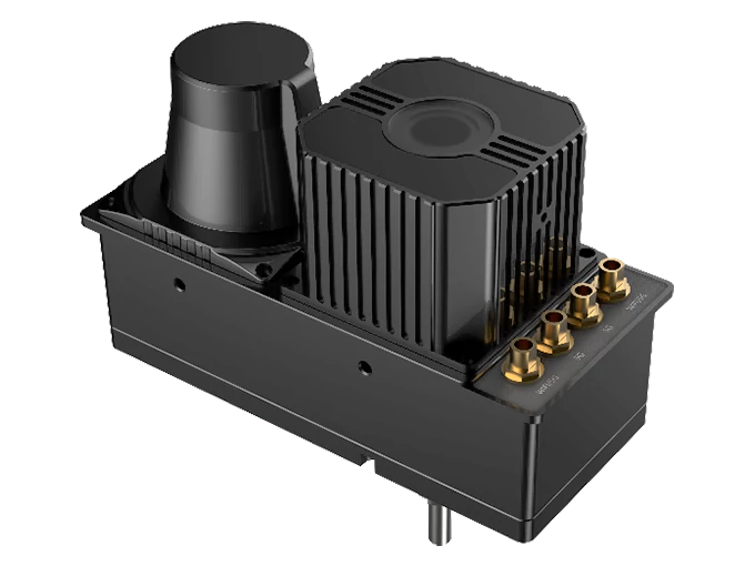
Yes, absolutely. The system is engineered for permanent mounting on moving vehicles with a compact design for long-term reliability on forklifts, AGVs, and AMRs.
For Underride AMRs: When applied to Underride (Latent) AMRs, a specific design is required to prevent the carried load from completely obstructing the upward-facing camera. This is typically achieved by using a raised mast or frame to ensure the necessary ceiling visibility is maintained.
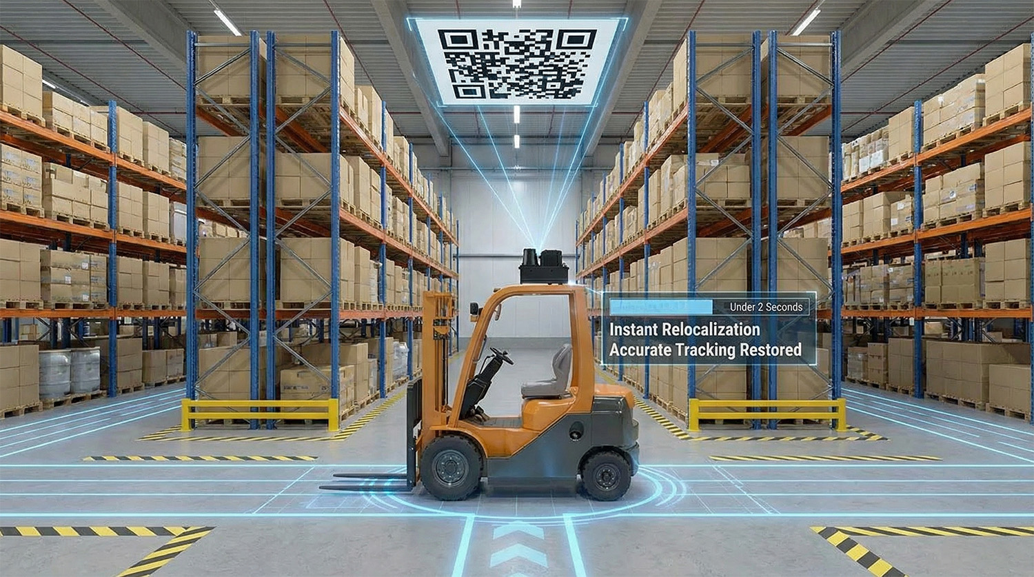
Location: Install the unit along the top of the vehicle (it need not be exactly on the centerline, as offset can be calibrated via extrinsic parameters). Ensure that neither the vehicle’s own structure (e.g., mast, overhead guard) nor typical loads permanently obstruct the field of view of the camera or LiDAR. If partial occlusion is unavoidable (e.g., due to a high mast or stacked loads), select a mounting position that minimizes the blocked area of both sensors.
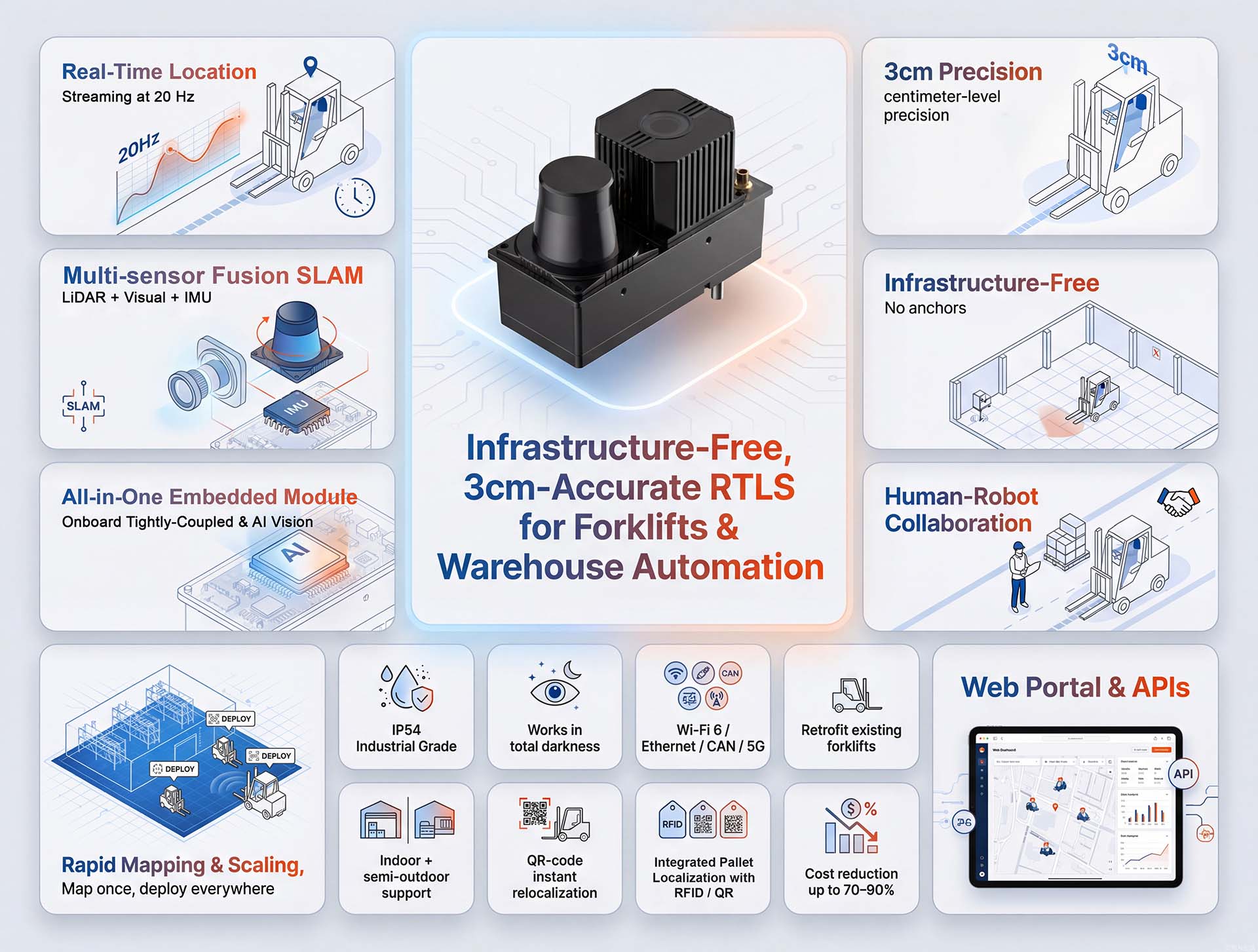
Orientation: It is recommended to mount the module with its long axis perpendicular to the direction of vehicle travel. This orientation aligns the camera’s 108° (H) × 57° (V) field of view to maximize horizontal coverage of the ceiling, capturing more environmental features for stable and reliable localization.
If mounting with the long axis perpendicular is not feasible, positioning the module with its short axis perpendicular to the direction of travel is also acceptable, though it may reduce the effective horizontal field of view for ceiling feature capture.

Installation Angle (Leveling): A near-horizontal angle (typically within ±2°) is recommended and does not require precision leveling tools. If the angle deviation exceeds ±2°, especially in environments with higher ceilings, it may lead to increased positioning errors.
No. The module is designed for direct integration with the vehicle’s power system, operating on a standard 24V DC supply.
Our system provides the essential core technology to enable pallet or goods location tracking, but it is not a complete, standalone tracking system. Reliable pallet tracking is achieved by combining two key pieces of information:
- The vehicle’s precise location (which we provide);
- The specific pallet’s identity (which you integrate) with some identification technologies (such as RFID readers or barcode scanners).
Implementation:
Your system logic then fuses the vehicle’s real-time location with the scanned pallet ID at the moment of interaction (e.g., pickup or drop-off) to establish a complete and accurate tracking record.
Important Clarification: Technologies for pallet identification (RFID, scanning, etc.) are not included within our positioning module. These are mature, off-the-shelf components that you select and integrate based on your specific workflow.
If you need support in integrating such technologies with our positioning system, we can refer you to our network of certified integration partners in your region. Please contact our sales or support team for further assistance.
Yes. To output real-time positioning data to the vehicle’s controller or a fleet management system, a local network connection is required. The system supports multiple connection methods to suit different deployment environments:
- Ethernet (wired): The primary and recommended interface for maximum reliability and bandwidth.
- Wi-Fi (wireless): Integrated Wi-Fi support provides flexibility where cabling is impractical. The module includes a standard antenna port for external Wi-Fi antenna connectivity. For Wi-Fi configuration steps.
- 5G Connectivity (optional): For wide-area mobility or sites without local Wi-Fi coverage, an optional 5G module can be integrated. The unit provides both a dedicated antenna port and a SIM card slot to support this capability.
The Intelligent Web Portal is focused on core operational management, including mapping, real-time monitoring, fleet control, and system diagnostics. It logs operational data (such as vehicle trajectories) but does not perform advanced business analytics, such as path optimization, efficiency reporting, or in-depth performance analysis. These higher-level functions are typically handled by upper-layer systems (e.g., WMS or ERP) that consume data via our open APIs.
If you require such advanced analytics capabilities, we can refer you to thirdparty solution partners specializing in logistics analytics and optimization, who can integrate with our system to provide those insights.